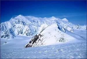
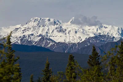
Mt. Logan is situated in the remote St. Elias Range of North Western Canada in the Yukon Territory. It is the crown jewel of Kluane National Park and is a UNESCO World Heritage Site. Logan is the highest point in Canada, and though second in North America only to Mount McKinley, is described as a more spectacular mountain without the crowds. The Logan massif rises about 3,000 m from the surrounding glaciers and has the largest base circumference of any mountain on Earth. A glaciated plateau, about 20 km long and 5 km wide covers the top of the massif, and due to active tectonic uplifting, Mt. Logan is actually still rising in elevation.
Due to its proximity to the Gulf of Alaska, severe snow storms can hit the upper part of the mountain any time of the year. Temperatures are extremely cold on and near Mount Logan. On May 26, 1991 a record -77.5 °C (-106.6 °F) was observed, making it the coldest recorded temperature outside of Antarctica. (It is not counted as the coldest temperature in North America since it was recorded at a very high altitude.)
Mt. Logan. 5,959 metres. 19,551 feet
Mt. Logan was first climbed on June 23, 1925 by
A.H. MacCarthy, H.F. Lambart, A. Carpe,
W.W. Foster, N. Read and A. Taylor
| Attribute | Details |
|---|---|
| Altitude | 5,959 m, 19,551 ft |
| Location | 60° 34′ 00″ N – 140° 23′ 00″ W |
| NTS Map | 115C09 McArthur Peak, 115C/10 King Peak |
| Calendar | April 15 – May 30 |
| Parks | Kluane National Park and Reserve of Canada |
| Fast Facts | CAPITAL: Whitehorse, Yukon PROVINCIAL FLOWER: Fireweed PROVINCIAL BIRD: Raven PROVINCIAL TREE: Subalpine Fir |
| Web Links | www.summitpost.org qsc.nrcan.qc.ca www.bivouac.com www.peakware.com |
History
By anyone’s standards the scale of the Logan Massif is truly awe-inspiring. Many experienced Himalayan climbers have said that they always thought they had seen truly gigantic peaks in their lives until they had their first glimpse of Logan. It absolutely soars some 3000 m higher than the surrounding glaciers and peaks and many people remark how it completely occupies the horizon even from a great distance.
Автор: Arthur T. LaBar – flickr.com
Dimensions
Logan is the largest ice sheet not part of an ice cap in the world, it has about a dozen peaks that rise from its summit plateau which itself is about 20 km long and 5 km wide and totally dominates the top of the massif. To top this off many of the peaks have their own sub-peaks, and there are dozens of ridgelines, many of which have never been climbed or even attempted. It is the “largest” mountain in the world.
Located in the St. Elias Mountains in the Yukon, at 5,959 metres, Mount Logan is second only to Mount McKinley (6,194 metres) in Alaska, the highest elevation in North America.
In 1890, I.C. Russell of the U.S. Geological Survey, while undertaking a survey in the St. Elias Mountains, named Mount Logan for Sir William Edmond Logan (1798-1875). Born in Montréal and educated in Scotland, Logan founded the Geological Survey of Canada in 1842.
The St. Elias Mountains were named in the late 1800s after Mount St. Elias. Its name was derived from Alaska’s Cape St. Elias, which, in turn, had been named by the Danish explorer Vitus Bering on St. Elias Day in 1741. Mount St. Elias is on the western boundary of Canada and, at 5,489 metres, is our second-highest mountain. In fact, the next sixteen highest mountains in Canada are all in the St. Elias Mountains, and all but one are in the Yukon. Fairweather Mountain (at 4,663 metres, the eighth-highest in Canada) straddles the B.C.-Alaska boundary. James Cook during his historic voyage along the west coast in 1778.
Routes
All expeditions planning to climb Mount Logan in Kluane National Park and Reserve must have an Ice Fields Permit. Climbers must apply to participate in the expedition. Individuals intending to lead an expedition must obtain a license by requesting the Kluane National Park and Nature Reserve Guide License Package.
Through Canada
Fly out of Silver City on Kluane Lake, north of Haines Junction. Both helicopters and light fixed-wing aircraft on ski-wheels are normally available in the Yukon at Haines Junction, Kluane National Park & Reserve Lake and Burwash Landing.
East Ridge
Fly onto Hubbard Glacier. The East Ridge is the best alpine climb: 4,000 meters (12,000 feet) up a superb narrow ridge. Perfect camp spots show themselves every 300 meters or so. The ridge is never too technical but always interesting.
Kings Trench
Fly onto Quintino Sella Glacier. This was the first-ascent route in 1925, which was a major tour-de-force for its time due to how far the climbers had to travel before even reaching the peak.
From Whitehorse fly out of Kluane Lake to Charter from Kluane Lake to Quintino Sella Glacier.
| Camp | Altitude | Location Description |
|---|---|---|
| Camp 1 | 9,000 ft | King’s Trench Quintino-Stella Glacier |
| Camp 2 | 11,000 ft | King’s Trench Camp |
| Camp 3 | 13,500 ft | King Col |
| Camp 4 | 16,000 ft | Football Field |
| Camp 5 | 17,000 ft | Windy Camp going up Ion Col |
| Camp 6 | 17,600 ft | Plateau Camp to Summit |
Safety and Preparedness at Mount Logan
Mount Logan’s extreme conditions demand careful preparation and awareness for anyone planning to climb or hike in the area.
Essential Gear for Climbing Mount Logan
Proper gear is critical for safety on Mount Logan. Here’s a list of essential items:
- Insulated, Waterproof Clothing: Dress in layers to manage body temperature and protect against hypothermia. Include a waterproof and windproof outer layer.
- Climbing Harness: A must for roped climbing, ensuring safety if you slip or fall on steep slopes.
- Ice Axe and Crampons: These are essential for navigating icy surfaces and securing your footing.
- GPS Device and Maps: Navigational tools are crucial in the vast and often disorienting terrain of high mountains.
- Satellite Phone or Communication Device: In case of emergency, you need a reliable way to communicate with rescue services.
Preparing for Extreme Weather
Weather on Mount Logan can be unpredictable and severe. Here’s how to prepare:
- Check Weather Forecasts: Always check the weather forecast before your trip and be prepared for sudden changes.
- Carry Emergency Shelters: Portable shelters such as a tent or bivy sack can be lifesavers during unexpected storms.
- Thermal Blankets: Lightweight and compact, these can help retain body heat in case of an emergency.
Survival Tips for Emergencies
In case of an emergency, remember the following tips:
- Stay Calm: Keeping a clear head can help you assess the situation and make rational decisions.
- Use Your Emergency Kit: Always carry a basic survival kit that includes a first aid kit, a whistle, a fire starter, and a mirror for signaling.
- Signal for Help: Use mirrors, bright clothing, or fires to signal your location to rescuers.
Additional Recommendations
Finally, always inform someone of your travel plans, including route details and expected return time. Participate in a mountaineering course if you are new to high-altitude climbing, to learn about acclimatization, weather patterns, and emergency procedures.
Conclusion
Notorious for its harsh environmental conditions, including some of the lowest temperatures recorded at high altitudes, Mount Logan offers a formidable challenge, demanding top-notch equipment and thorough strategic planning from those who dare to ascend it. Mount Logan is a landmark of both geographical and historical significance, named in honor of Sir William Edmond Logan, the esteemed founder of the Geological Survey of Canada, with the mountain continuing to elevate due to tectonic forces. A variety of ascent routes are available, from the complex East Ridge climb to the more navigable ski ascent via the King’s Trench, all requiring detailed permits and rigorous safety measures. Compliance with strict safety and preparedness protocols is imperative, including the provision of emergency shelters, utilization of GPS navigation, and secure communication options to handle any sudden meteorological shifts or critical situations.
FAQs
What makes Mount Logan a challenging climb?
Due to its extreme altitude and some of the coldest temperatures recorded outside Antarctica, Mount Logan requires climbers to have high-quality gear, thorough preparation, and experience in navigating harsh mountainous environments.
How is Mount Logan still rising?
The mountain is located in an area of active tectonic uplifting, meaning that geological forces are gradually increasing its elevation. This ongoing process is part of what makes the St. Elias Range geologically fascinating.
What are the most popular routes to climb Mount Logan?
The East Ridge and the King’s Trench are two of the most popular climbing routes. The East Ridge offers a more technical challenge, while the King’s Trench is preferred for its less technical, ski-based ascent.
What permits are required to climb Mount Logan?
Climbers need to obtain several permits, including an Icefields Permit, and potentially an Aircraft Landing Permit if the expedition involves air transportation. These permits help manage the ecological impact and ensure the safety of the climbers and the environment.