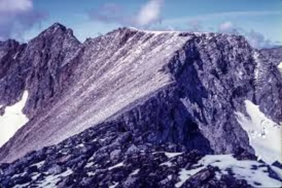
Author: Charlie Munick – wikimedia.org
The border between Quebec and Labrador is defined as the watershed divide between rivers flowing east to the Atlantic and those flowing west into Ungava Bay. This peak, the highest point on this divide, was unnamed until 1971. The name “Mont d’Iberville” was given to this never-climbed mountain by the Quebec Toponym Commision in that year.
Mount D’Iberville. 1,652 metres. 5,420 feet
| Attribute | Details |
|---|---|
| Altitude | 1,652 m, 5,420 ft |
| Location | 58° 43′ N, 63° 43′ W |
| NTS Map | O14L1 O14L13 Cirque Mountain 14 M/4 Nachvak Fiord |
| Calendar | August or September |
| Parks | N/A |
| Fast Facts | CAPITAL: Quebec City, Quebec PROVINCIAL FLOWER: Blue Iris PROVINCIAL BIRD: Snowy Owl PROVINCIAL TREE: Yellow Birch |
| Web Links | Nunavik Parks – Trek Mont Iberville Peakbagger – Mountain Info Andrew Lavigne’s Outdoor Adventures – Torngats |
History
The highest summit in Quebec, at 1,652 metres, is Mont d’Iberville in the Torngat Mountains. This name was given in 1971 by the Commission de toponymie du Québec for Pierre Le Moyne d’Iberville (1661-1706). D’Iberville led many ruthless expeditions in North America, including a destructive rampage in St. John’s and the Avalon Peninsula of Newfoundland in 1696 and 1697. Pierre LeMoyne Sieur d’Iberville was a French officer who twice burned all of Newfoundland’s major towns to the ground.
In 1981, the Newfoundland Geographical Names Board ascertained that the peak so named was on the Quebec-Labrador boundary and decided that it should be assigned a name more suitable to that region’s history. The board gave it the name Mount Caubvik in honour of one of the five Inuit who accompanied George Cartwright, a trader on the Labrador coast, to England in 1772. So it is no coincidence that the heights of the highest points in Quebec and Newfoundland are identical: they are the same feature, but with two quite different names.
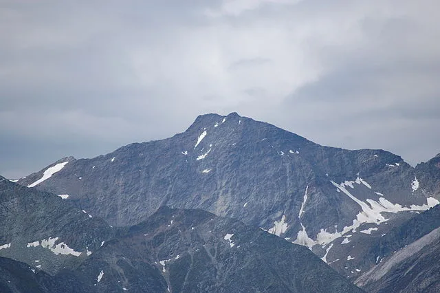
Author: Michael Kranewitter – wikimedia.org
Routes
Drive to Goose Bay, NF, take a PAL flight to Nain and charter a boat to Nachvak Fjord. Requires 2 days of travel and a 7 month advance reservation. Boat would return in 7 days for pickup. Climb to summit would take approximately 4 or 5 days. Estimated cost $1000/return.
Alternative Route
For a different approach and climb, check out the route taken by the CanaTREK Summits of Canada Team in July & August, 2014. This requires flying in to the headwaters of the Koroc River via Twin Otter plane. The flight can be scheduled from Kangiqsualujjuaq (George River). Summit route used the Koroc Ridge, and descent was along the Minaret Ridge. See details including planning resources/guides, photos, and an interactive GIS map (with GPS marked route, topographic and satellite views, etc.).
Safety Tips and Required Gear
The journey to Mont d’Iberville/Mount Caubvik is not only an adventurous pursuit but also one that comes with potential hazards due to its remote and challenging environment. To ensure a safe and enjoyable experience, it is crucial to be well-prepared and to adhere to safety guidelines tailored for this particular trek.
Essential Safety Tips
- Plan Ahead: Before you embark on your journey, make sure to research thoroughly and prepare an itinerary. Inform someone of your plans and expected return time.
- Weather Awareness: The weather in the Torngat Mountains can be unpredictable. Always check the weather forecast before starting your trek and be prepared for sudden changes.
- Emergency Procedures: Familiarize yourself with basic emergency procedures and first aid. Carrying a basic first aid kit is essential. Know the symptoms of hypothermia and altitude sickness.
- Communication Devices: Since this is a remote location, cell phone reception may be unreliable. It is advisable to carry a satellite phone or a GPS emergency beacon.
- Respect Wildlife: The area is home to wildlife including bears and caribou. Keep a safe distance from animals and store food securely to avoid attracting them.
Recommended Gear
Packing the right gear is critical for your safety and comfort during the trek. Here’s a list of essential items to bring along:
- Appropriate Clothing: Dress in layers to manage body temperature effectively. Include a waterproof and windproof jacket. Don’t forget gloves and a hat.
- Footwear: Durable, waterproof hiking boots are a must. Make sure they are well-broken-in to avoid blisters.
- Navigation Tools: A detailed map of the area, a compass, and a GPS device. Ensure you know how to use them.
- Food and Water: Bring enough high-energy food and water for the trek. Consider a portable water purifier or water purification tablets.
- Sleeping Gear: A lightweight, weather-resistant tent, a sleeping bag suitable for low temperatures, and an insulated sleeping pad.
- Climbing Equipment: Depending on the route, you might need specific climbing gear such as ropes, harnesses, and carabiners.
- Lighting: A reliable headlamp with extra batteries. The area can get very dark at night.
- Sun Protection: Sunglasses, sunscreen, and a sun hat are essential to protect against UV rays.
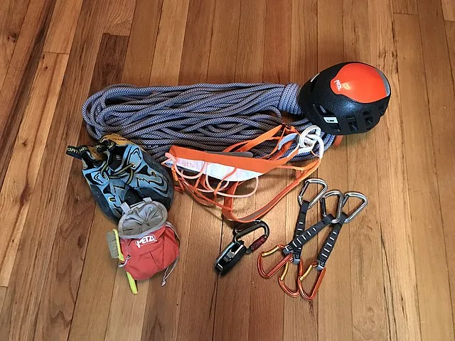
Author: Climber Ben Johnson – wikimedia.org
Accommodation Options
Camping Sites
For those who prefer to be close to nature and enjoy the wilderness, camping is the most immersive option. There are several designated camping areas around the Torngat Mountains National Park, which offer basic amenities such as pit toilets and fire pits. It is important to note that these sites do not have running water, and campers must be fully self-sufficient. Carrying a sturdy tent, sufficient food supplies, and a way to purify water is necessary. Always follow Leave No Trace principles to minimize your impact on the natural environment.
Lodges and Cabins
If you’re looking for something a bit more comfortable, there are lodges and cabins available within a reasonable distance of the mountains. These facilities provide basic to moderate amenities, including beds, heating, and sometimes meals. It’s a good idea to book these well in advance, especially during the peak season of July and August, as they can fill up quickly.
Hotels
In larger towns such as Goose Bay, there are more traditional hotel options. These hotels offer a range of services from simple rooms to suites with various amenities like Wi-Fi, private bathrooms, and breakfast. Hotels are a good choice if you prefer to prepare for your trek in comfort or recover after your adventure.
Traveler’s Hostels
These hostels often offer shared accommodations and cooking facilities, which can be great for meeting other travelers and exchanging tips and stories about your adventures.
Local Guest Houses and B&Bs
Several small towns and villages near the access points to Mont d’Iberville offer guest houses and bed-and-breakfast accommodations. These are often family-run and provide a cozy, homely atmosphere. Staying at a B&B can also give you a taste of local culture and hospitality, with the chance to try homemade meals and local cuisine.
Planning and Booking
Given the remote location, it’s crucial to plan your accommodation well in advance. Always confirm your booking before setting out, and consider your schedule and how it aligns with your trekking plans. Make sure to check the availability of amenities and services during your stay, and always have a backup plan in case of unexpected changes.
Choosing the right accommodation will enhance your experience and provide you with the necessary rest and comfort needed for a challenging trek in Mont d’Iberville/Mount Caubvik. Whether you choose the ruggedness of camping or the comfort of a hotel, ensure it suits your needs and allows you to enjoy the breathtaking surroundings to the fullest.
Conclusion
Mont d’Iberville, also known as Mount Caubvik, is the highest peak in Quebec and Newfoundland, located on the Quebec-Labrador boundary. The mountain was named in honor of Pierre Le Moyne d’Iberville in 1971 by the Quebec Toponymy Commission and later renamed Mount Caubvik in 1981 to reflect local Inuit heritage. Accessing the summit involves extensive travel, including driving, flying, and a possible boat charter, with several days required for the climb. Safety precautions are critical due to the mountain’s remote and challenging environment, requiring proper gear and awareness of weather and wildlife. Accommodation options range from camping in the wild to staying in lodges, cabins, or hotels in nearby towns, suitable for different preferences and budgets.
FAQs
Why are there two different names for the mountain?
Originally named after the French explorer Pierre Le Moyne d’Iberville in 1971 by Quebec’s naming authority, the mountain was renamed Mount Caubvik in 1981 by Newfoundland’s geographical board to honor the Inuit cultural heritage of the area.
What months are most suitable for summiting Mont d’Iberville/Mount Caubvik?
The peak climbing conditions are typically in August and September due to relatively stable weather, although climbers should always prepare for possible sudden weather changes.
Can you list the critical gear needed for a successful climb?
Key gear includes weather-appropriate layered clothing, sturdy waterproof boots, navigation aids like maps and GPS, high-energy provisions, ample water plus purification methods, a sturdy tent, cold-weather sleeping bag, a comprehensive first aid kit, and emergency communication devices.
Do climbers need special permissions or permits?
Access to Mont d’Iberville/Mount Caubvik may require permits, especially when entering protected park areas. It’s vital to consult with park officials or local authorities in advance to obtain any necessary permissions and ensure adherence to local regulations.